
There’s a proposal on the table for future development of land west of the Okotoks cemetery.
Council gave first reading to the West Okotoks Area Structure Plan on Jan. 13 ahead of a public hearing to be held on Jan. 27.
“The intent of the area structure plan is to provide framework for subsequent subdivision development in the area,” said Colin Gainer, senior planner with the Town of Okotoks.
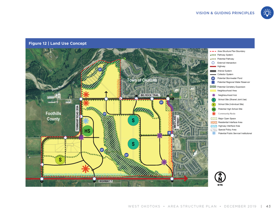
The area is comprised of 428.6 hectares of land bordered by Westland Street to the east, Highway 7 to the south, Big Rock Trail and the Sheep River to the north and 16 Street West to the west, following the Town boundaries since annexation in 2017.
It includes a natural wetland currently on the land. The proposed area structure plan also indicates land for three school sites, a potential high school site, commercial centres, medium-high density residential areas, and a diverse range of housing types and neighbourhood parks, as well as potential for expanding the current cemetery on the west side of Westland Street.
The proposed West Okotoks Area Structure Plan (WOASP) replaces the existing Sandstone Springs Area Structure Plan, said Gainer.
“The plan was developed over a significant crossroads in the Town’s history with the annexation decision, environmental master plan, as well as our new municipal development plan all coming in to being active plans,” said Gainer.
With the Town currently finalizing its new Municipal Development Plan (MDP), he said the WOASP can be reviewed and amended as necessary to comply with the new plan.
Some of the items that may not align perfectly with the new MDP could be housing density and housing style mix, he said. The number of homes per acre could change depending on how the MDP is finalized.
“This plan will be updated to make sure there is consistency,” said Gainer.
At this time the plan is very high-level, as it focuses on a general outlook for the neighbourhood. Detailed design elements will come forward at a later date, he said.
There will be some changes to traffic flow with the development of a new subdivision on the WOASP lands, he said. One of the proposed changes is Westland Street will be closed off at Big Rock Trail.
“This kind of main access in the area would be replaced with a new primary collector further to the west,” said Gainer.
Mayor Bill Robertson brought forward the concern of a resident currently living in the area, who he said is worried about the amount of traffic that will be generated along Big Rock Trail.
“The resident, on behalf of a lot of residents, felt that noise would warrant a noise attenuation device going along there now because of the sound,” said Robertson.
He said there were requests for a wall barrier to be built along Big Rock Trail to alleviate traffic noise.
In addition, he said there are concerns about heavy truck traffic traveling through Okotoks to access the chicken farm located on Big Rock Trail in Foothills County.
“There has been a recent report I have been made aware of from municipal enforcement regarding heavy truck traffic along that road,” said Robertson.
Gainer said concerns over truck traffic would have to be handled separately from the WOASP in conjunction with Foothills County.
As far as sound attenuation, he said the area structure plan indicates analysis of potential impacts would be completed at the outline plan stage, when more detailed design of the lands would come forward.
“The plan itself speaks to the likelihood of some sound attenuation but exactly what would be required and what that detail looks like, that would be determined at a later date,” said Gainer.


