
Traffic and water topped the list of resident concerns for the proposed West Okotoks Area Structure Plan.
Council gave second reading to the area structure plan on Jan. 27 after hearing from members of the public. The plan will now go before the Calgary Metropolitan Region Board for approval prior to coming back before Okotoks council for third reading of the bylaw.
“The intent of the area structure plan is to provide framework for subsequent subdivision development in the area,” said Colin Gainer, senior planner with the Town of Okotoks.
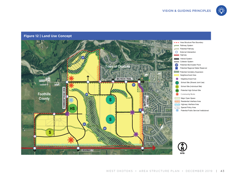
The area is comprised of 428.6 hectares of land bordered by Westland Street to the east, Highway 7 to the south, Big Rock Trail and the Sheep River to the north and 16 Street West to the west, following the Town boundaries since annexation in 2017.
It includes a natural wetland currently on the land. The proposed area structure plan also indicates land for three school sites, a potential high school site, commercial centres, medium-high density residential areas, and a diverse range of housing types and neighbourhood parks, as well as potential for expanding the current cemetery on the west side of Westland Street.
The proposed West Okotoks Area Structure Plan (WOASP) replaces the existing Sandstone Springs Area Structure Plan, said Gainer.
“The plan was developed over a significant crossroads in the Town’s history with the annexation decision, environmental master plan, as well as our new municipal development plan all coming in to being active plans,” said Gainer.
With the Town currently finalizing its new Municipal Development Plan (MDP), he said the WOASP can be reviewed and amended as necessary to comply with the new plan.
Some of the items that may not align perfectly with the new MDP could be housing density and housing style mix, he said. The number of homes per acre could change depending on how the MDP is finalized.
“This plan will be updated to make sure there is consistency,” said Gainer.
At this time the plan is very high-level, as it focuses on a general outlook for the neighbourhood. Detailed design elements will come forward at a later date, he said.
There will be some changes to traffic flow with the development of a new subdivision on the WOASP lands, he said. One of the proposed changes is closing off Westland Street at Big Rock Trail.
“This kind of main access in the area would be replaced with a new primary collector further to the west,” said Gainer.
Area resident Mary Lynn Maher said the idea was flawed because it has the potential to drive more traffic toward Westmount School, which is already congested.
“What that’s going to do is create traffic going west and then north, past a school zone that is narrowed to only one lane in that direction, and then it narrows again at the top of the hill,” said Maher.
She suggested closing off the road at the peak of the hill on Westland Street rather than at the cemetery to divert some traffic up Westridge Drive.
Deb Goossen, who lives in the Sheep River neighbourhood, said she’s equally concerned about increased traffic levels along Big Rock Trail, particularly around Big Rock Elementary School and outside her own back door.
She said Big Rock Trail has never been well-managed.
“I have been, and all of my kids, almost picked off at that crosswalk at the cemetery to Big Rock School many times,” said Goossen. “It’s always, I think, any of us who live backing onto it, it’s been a bone of contention.”
Matters have been made worse with increased truck traffic heading to the chicken farm on Big Rock Trail, she said.
Mayor Bill Robertson said the matter of farm and transport trucks travelling into town from the chicken farm is one that needs to be worked out with the Town’s partner, Foothills County. It was put onto the agenda for an intermunicipal development committee meeting between the two municipalities, he said.
“We actually have an agreement ,we don’t allow regular truck traffic,” said Robertson. “We’d rather have heavy trucks use Highway 7 and so on. There have been some concerns recently, it’s been brought up so we’ll be discussing that.”
Gainer said changes and upgrades on Big Rock Trail will be conducted as necessary, depending on how quickly the area develops. It is intended to be phased, with the first phase being along Westland Street and Big Rock Trail.
As development moves out west, more improvements will be made to the roadway and intersections, and it will continue to be assessed on a regular basis, he said.
Carrie Fritz, who also lives in Sheep River, said she didn’t think the development was very well thought-out.
“The area structure plan is a blueprint for the west area of Okotoks and there really does need to be more thought and vision,” she said. “Transportation, infrastructure and of course water really do require more thought.”
Her concerns over water allocation were echoed by several residents at the public hearing.
Rahim Lakhoo, vice-president land of Tristar Communities, said the developer has been in constant conversation with the Town over water.
At this time there is enough water licence for 100 acre feet of development, and a typical phase of a community would be about 20 to 25 acres, he said.
“I believe the Town is working very hard to get a long-term solution to the water provision,” said Lakhoo. “We as developers are confident this town will have its water problem solves, which will certainly help us.”
Coun. Tanya Thorn said she liked the neighbourhood hubs and use of municipal reserve land to co-locate schools in the West Okotoks Area Structure Plan. She said after five years, the plan has a lot of promise for a good-quality community in Okotoks’ southwest end.
However, like many residents in the area, she said she’ll be watching traffic impacts closely as phases move forward.
“That would probably be my highlighted concern is the transportation corridor,” said Thorn. “I’ll be paying attention to that as we move forward through the outline stages.”
Residents will also have the opportunity to be further involved in the development process as it moves ahead to next stages.
“For folks in the community who are still uncertain about some parts of the plan, rest assured there are many, many steps between today and the first house being built,” said Coun. Ed Sands.


